New Collaborative Mapping Layers

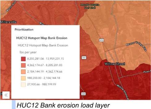
The Partners are excited to offer 6 new layers as part of the Collaborative Mapping Tool Version 3.0! As part of their work under the NFWF Crescendo in Collaboration grant, Water Science Institute (WSI) developed new GIS layers from their LiDAR differencing. WSI’s layers help us understand erosion and sediment deposition in our stream valleys. Precise decision-support tools like these improve potential project site selection for more efficient and cost-effective watershed restoration projects. We’re excited to offer advanced tools publicly and a collaborative mapping tool that also offers exceptional quality spatial information on planning efforts, hydrology, water quality, policy, land use & cover, and projects all in one place.
Check out the Final Report & User Guide to learn how these layers were developed and to better understand how they can be used to identify restoration sites. These are tools that will ultimately help us select the right conservation practice for the right location and site conditions.
To view the layers go to the Partner’s mapping tool at https://lcwp.cicapps.org/, then:
- Check that the “Implementation” tab is selected
- Select the “Priority” category checkbox
- Choose which layer to view (radio buttons):
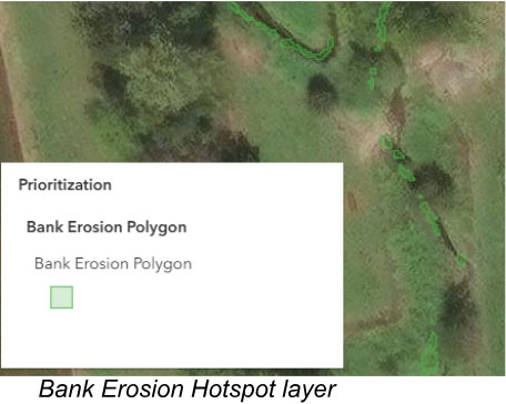
- HUC12 Streambank Erosion Hotspots
- Valley Bottom Bank Erosion Heatmap (wide)
- Valley Bottom Bank Erosion Heatmap (narrow)
- Bank Erosion Hotspot polygons
- Legacy Sediment Terraces
- Mill Dams
A full list of data layers & description for the collaborative mapping tool can be found here.
For more on WSI’s work or for contact information, go to https://www.waterscienceinstitute.org/.